 Ten Toe Express

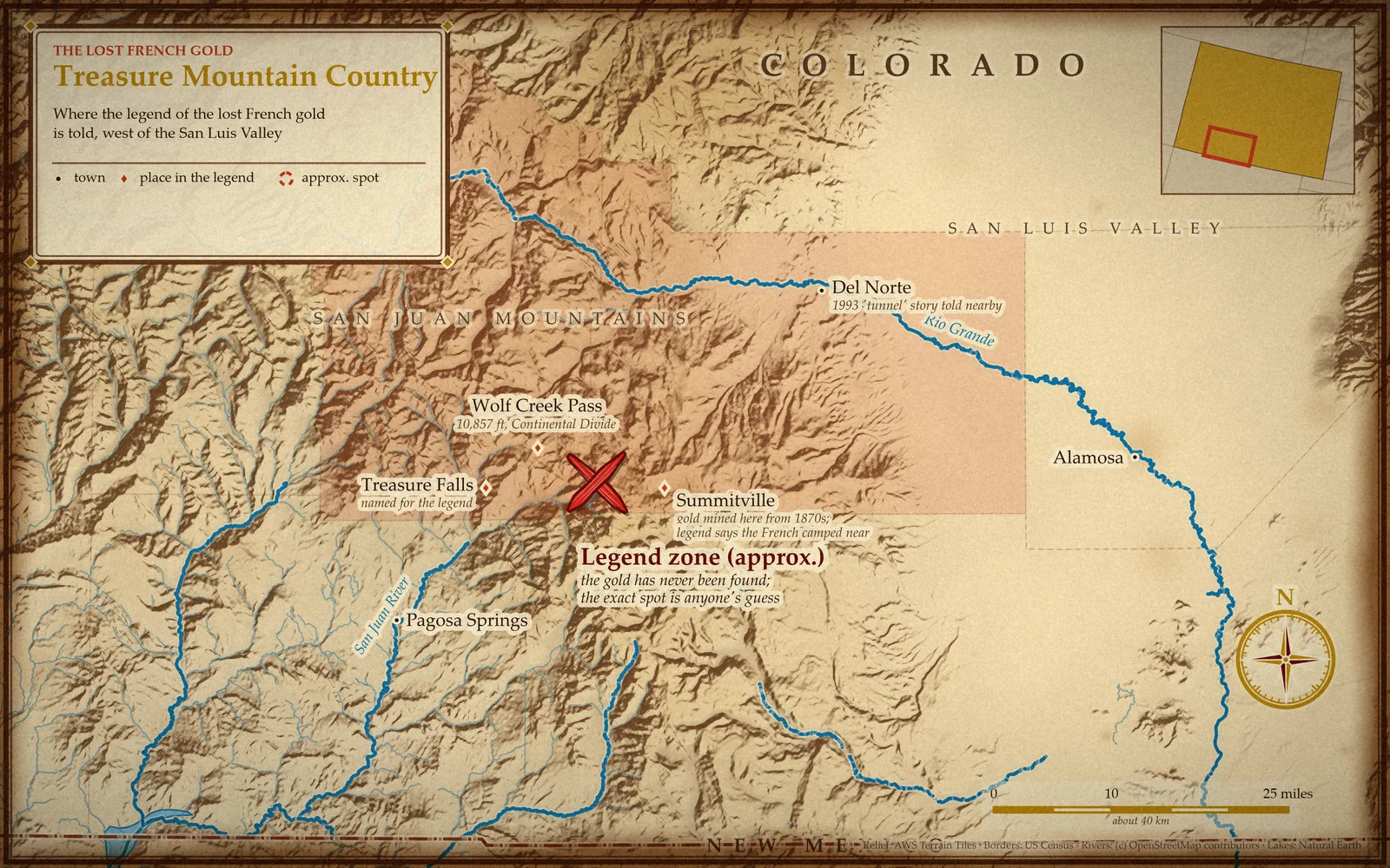
Drive over Wolf Creek Pass in southwestern Colorado and, about fifteen miles east of Pagosa Springs, you'll pass a 105-foot waterfall called Treasure Falls. The name isn't marketing. It comes from the Treasure Mountain lost French gold legend: a tale of hundreds of Frenchmen, a mountain full of gold, a battle in the snow, a map that crossed an ocean and a murder trial in Taos that ended in an acquittal.
Right then. Here's what's lost, what's rumour and what the sources can actually back up. Spoiler: the part about the gold is the part nobody can back up.
The Treasure Mountain legend in brief
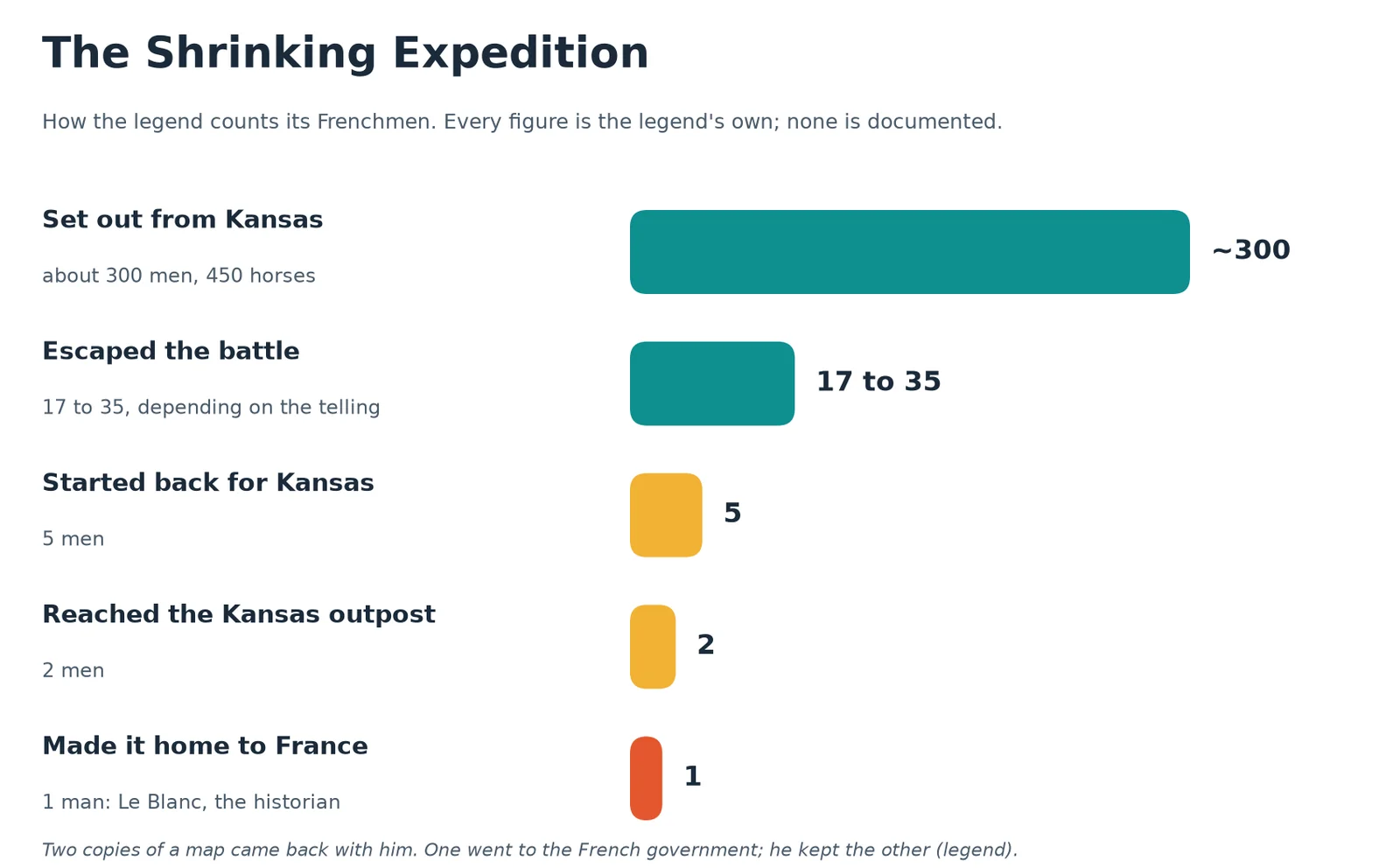
The story, as told in books and local lore, goes like this. In the late 1700s a French expedition of about 300 men and 450 horses left a small outpost near what is now Leavenworth, Kansas, and headed for the Rocky Mountains. Prospecting went badly at first. So the party worked its way south and made camp east of Wolf Creek Pass, near where the old mining town of Summitville would later stand.
There, the legend says, they struck it rich on Treasure Mountain. The haul was stashed in three places, and the commanding officer kept the map. Some versions have Napoleon himself sending the men to raise money for his ambitions, which is a spot of a problem, since Napoleon wasn't running France in the 1700s. That's your first clue that this is folklore rather than a case file.
The battle, the escape and one very lucky historian
The Native people of the area, the story says, left the visitors alone for a while. Then relations soured and a long fight broke out. Accounts disagree on who exactly attacked: the Utes are named in some, while one newspaper roundup describes Spaniards or Native Americans, which is fair, since the San Juan Mountains were Spanish territory at the time.
The French buried the gold, redrew their maps and fled. Most were killed, the legend says. Estimates of how many got away run from 17 to 35. Attacked again near the Front Range, only five set out on the long road back to Kansas. Winter and starvation took three. Two reached the outpost, and one of those died there.
That left the expedition's historian, Le Blanc, as the lone survivor. He sailed home to France carrying two copies of the treasure map: one for the French government, one for himself.
The second expedition and the Taos trial
France, naturally, wanted its gold back. A second party of about 50 men set out, possibly backed by Le Blanc's family or the government. They passed through Taos, New Mexico, hired a guide and vanished into the mountains. One version has them searching the Summitville area for three years without luck.
Then the guide turned up alone, saying Native warriors had wiped everyone out. People in Taos were suspicious, as people tend to be about a man who walks out of the wilderness with the whole expedition missing. He was tried for murder and acquitted. The story calls it the last Mexican trial held on what had become United States soil.
Here the legend sprouts a conspiracy theory. Perhaps the French had quietly found the gold, carted it home and paid the guide to spin a tale of massacre. One storyteller finds this unlikely, noting that French equipment was later found among Native people. Another says some of the gold might have been hidden near the mouth of the Rio Grande Canyon. A raised eyebrow is warranted for all of it. The record behind these details is thin: the trial's date is never given, and no document in the sources checked confirms the second party, the guide or the verdict.
The map hunters: Yule, Poor and a vanishing chart
Real names start appearing in the later chapters, though even these are repeated from the same handful of retellings. A man called William Yule is said to have owned a copy of the original map and searched the western side of the San Luis Valley, all the way north to Saguache, without success. Asa Poor then got the map from Yule and, with two partners, matched up some landmarks. No gold. One partner, Montroy, held on to the map, and it disappeared a few years later.
That is the standard fate of treasure maps. They are always lost, burned, stolen or "somewhere in the attic". Nobody has ever been reported to have lost a map that led straight to the money and then simply used it.
The 1993 cave story
The most recent chapter is also the strangest. A family claiming descent from Le Blanc says it holds an authentic map written in French and has searched for three generations. Telling the story in 1997, writer Christopher O'Brien gave the family a pseudonym. They say they have located seven of the eight landmarks on it.
The eighth, they say, turned up in 1993. A family member sheltering from rain while elk hunting south of Del Norte found a narrow opening that led to a man-made tunnel, partly blocked by a cave-in, with a carving on the wall they took for the missing clue. The next day about 20 relatives dug out the blockage and pushed further in. Then, as the tellings go, a rattlesnake lunged, bats poured out, a candle at the far end lit itself and a giant owl dived at the group. They left, quickly.
None of that has independent confirmation. It's a family's account, and a good campfire one. The same sources say the family claims state treasure rights to the spot, which is a claim you can read but not check.
What the record actually shows
Strip the story down and the hard facts are mostly about the neighbourhood, not the French. Gold really was found around Summitville: lode gold in 1871, a town founded in 1873. From 1873 to 1959 the Summitville mine produced about 257,600 troy ounces of gold. A Canadian company later ran a huge cyanide heap-leach operation there from 1986 to 1991. It went bankrupt in December 1992 and the site became a Superfund cleanup in 1994.
Wolf Creek Pass is real too. It tops out at 10,857 feet on the Continental Divide, and the first road over it was built between 1911 and 1916.
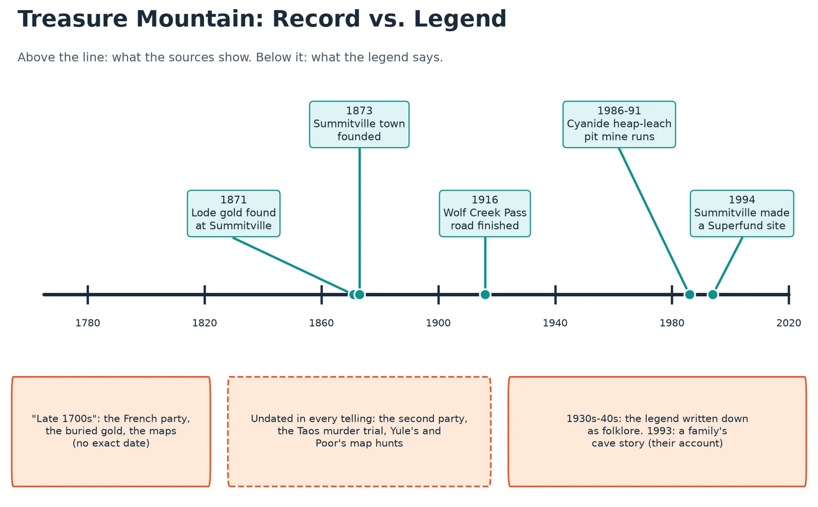
So there is genuine gold country here, with genuine mining history. What's missing is any paper trail for a French party, a Le Blanc, a three-cache gold hoard or a Taos trial. The legend also drifts in other ways. Two Colorado peaks carry the name: an 11,834-foot Treasure Mountain in Mineral County, and a far better-known 13,535-foot Treasure Mountain in the Elk Mountains of Gunnison County, where the story gets attached too in some places. One retelling even dates the burial to the late 1500s. For a legend that's supposed to be about a map, it can't seem to agree on a map.
Theories, weighed
- The gold is still up there. Possible in principle, but with no documentation for the expedition, there's nothing to say what "there" is.
- The French recovered it. This is the "patsy guide" theory. It neatly explains why nobody finds anything, which is also its problem: it explains everything and proves nothing.
- Someone else found it. The legend has Native people possibly hiding some near the Rio Grande Canyon. Pure speculation, and nobody offers evidence.
- The legend grew from real mining fever. The simplest explanation: with a real Summitville boom nearby, a tale of French gold would sound perfectly natural to a prospector's ear. Folklore about it was written down in the 1930s and 1940s, long after the mining rush.
Where it stands today
Nobody has confirmed finding the gold, and the story hasn't been shown to be true or false. It hangs on as Pagosa Springs lore, and Treasure Falls is the legend's most visible landmark. The falls sit right beside US 160, about 15 miles east of Pagosa Springs, just before the climb to Wolf Creek Pass, and a short, fairly easy hike of well under a mile leads to a viewing deck where you may get sprayed. Come in spring and the falls run strongest from snowmelt.
The country around is national forest, so there's no treasure-digging to be done. Go for the waterfall, the pass and the story, and leave the shovel at home.
...and if you find it, remember who encouraged your questionable life choices.
The short version of this story is on YouTube at @TenToeExpress.
Deep dive yourself
- Treasure Mountain, Colorado · Legends of America
- Treasure in the San Luis Valley: The golden horde, part II (Christopher O'Brien, 1997) · Cyberwest
- Treasure Mountain (Colorado) · Wikipedia
- Treasure buried in the 1700s behind namesake of stunning Colorado waterfall · Denver Gazette
- Summitville mine · Wikipedia
- Wolf Creek Pass · Wikipedia
- Treasure Falls · Team M-Squared, Pagosa Springs