 Ten Toe Express
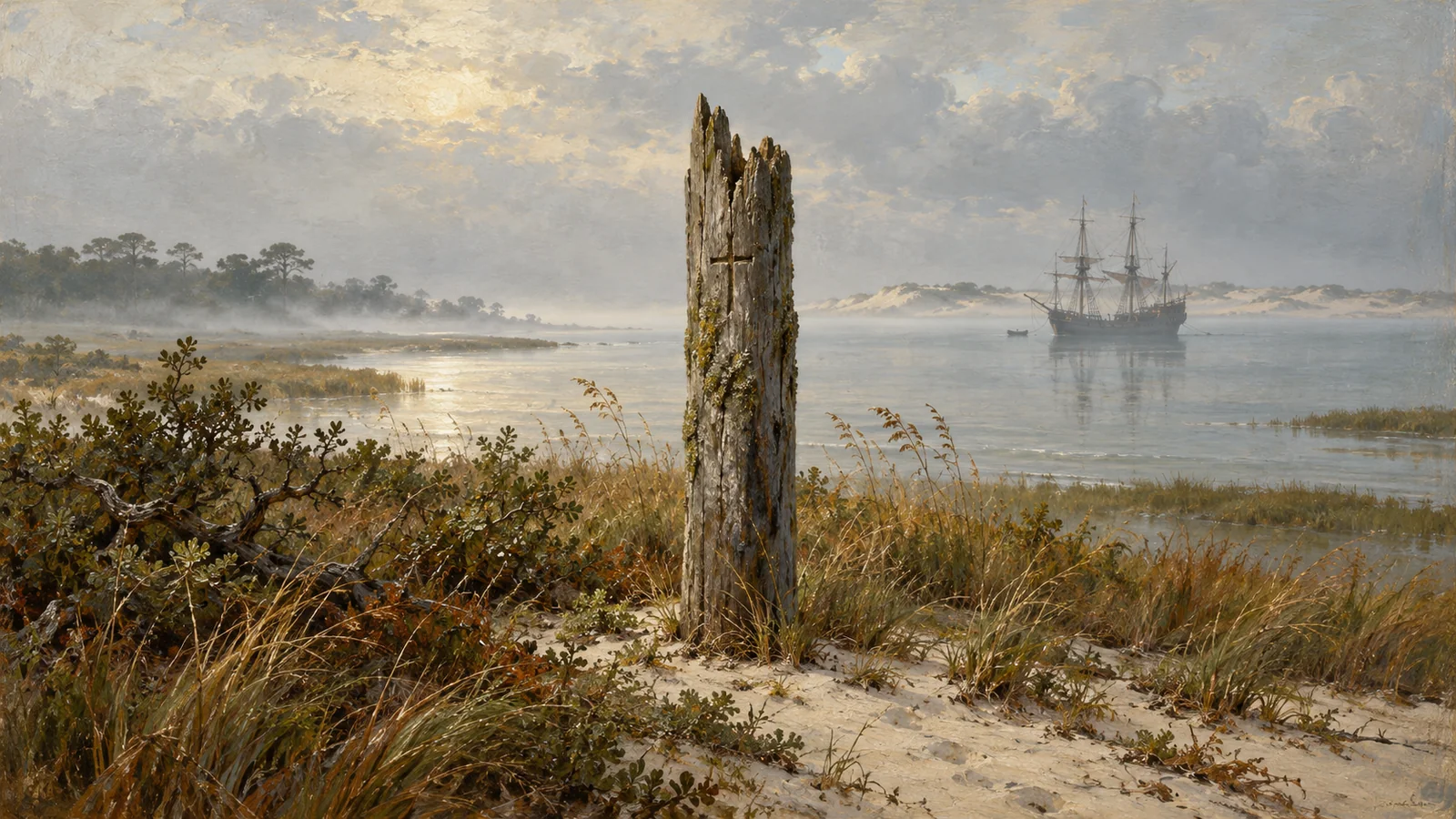
On 18 August 1590, an English sea captain named John White stepped onto Roanoke Island, North Carolina, with a head full of hope and a heart full of dread. Three years earlier he had left behind his daughter, his son-in-law and a brand-new granddaughter, along with roughly a hundred other English settlers. What he found was a fortified settlement with nobody in it, and one word carved on a post: CROATOAN.
That is the whole opening act of the Lost Colony of Roanoke, America's oldest and most stubborn disappearance mystery. No bodies. No battle. No note. Just a tidy, empty village and a word that has kept historians, archaeologists and cranks busy for more than four centuries. Right then, fancy a proper mystery?
Roanoke Island: England's first American attempt
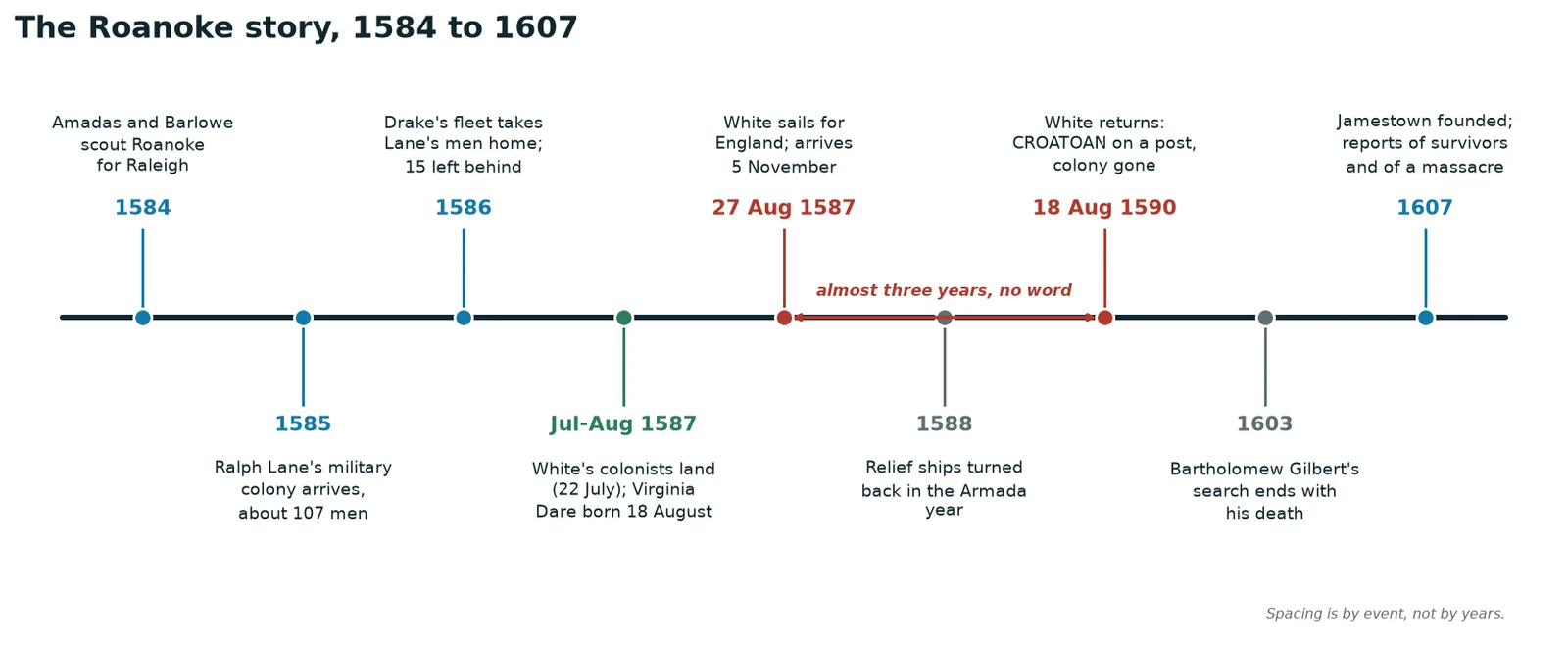
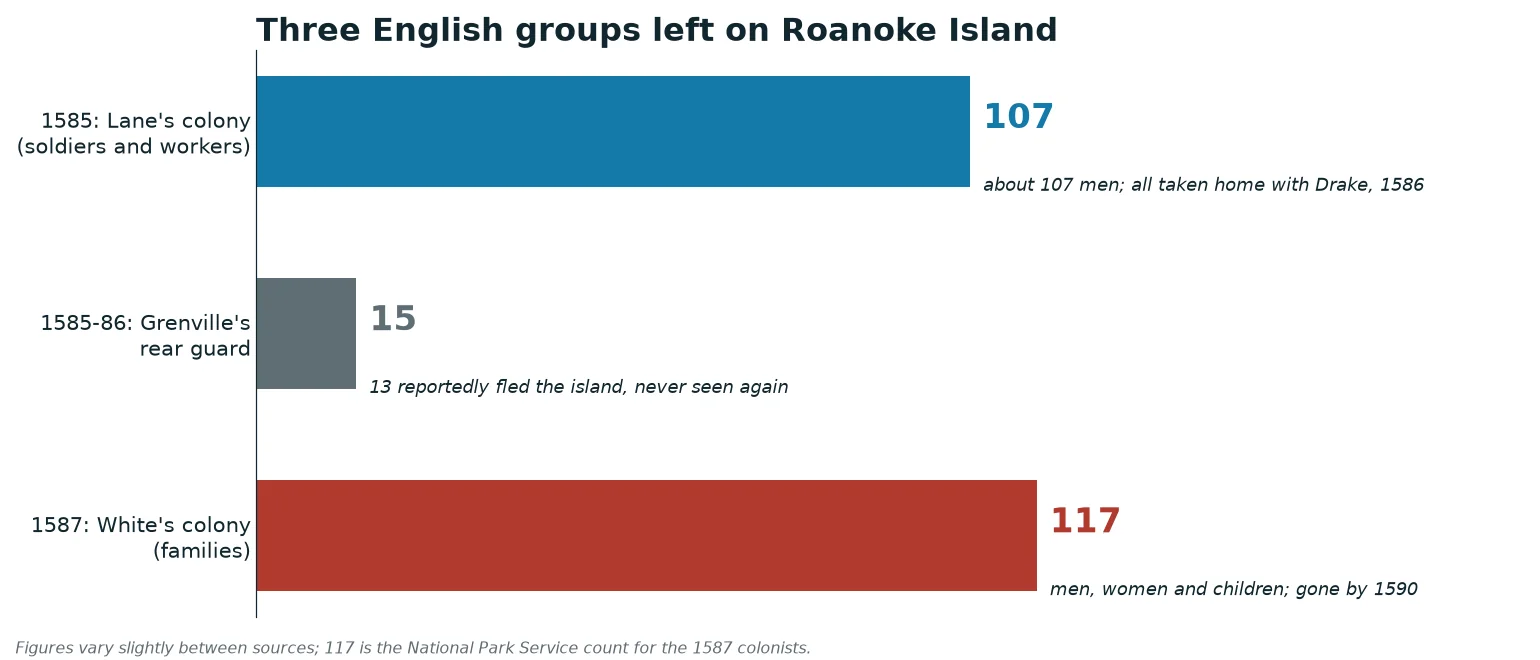
The queen's favourite, Sir Walter Ralegh, wanted a piece of the New World and a base from which English privateers could harass Spanish treasure ships. In summer 1584 his scouts reached Roanoke Island. In 1585 a bigger expedition returned, under Ralph Lane, to set up a military colony. That first effort, about 107 men, did not go brilliantly. Relations with the local Algonquian-speaking peoples soured, supplies ran thin, and in 1586 Sir Francis Drake's fleet turned up and carried Lane's men home.
A small rear guard of 15 men had been left behind earlier. According to what the Croatan people later told the English, 13 of them fled the island and were never seen again. Not a cheerful omen for the next group.
The 1587 colonists: families, not soldiers
The second attempt was different. This time the National Park Service describes 117 men, women and children led by John White, a gentleman-artist and Ralegh's chosen governor. Among them were White's pregnant daughter Eleanor and her husband Ananias Dare. They left England in May 1587 aboard three ships, and the plan was to settle on Chesapeake Bay.
The plan changed on 22 July 1587. A gentleman acting for the fleet's pilot, Simon Fernandes, ordered the sailors to leave the colonists at Roanoke instead of taking them on. So the settlers stayed put, a long way from where they had planned to be.
Things got moving fast. A colonist named George Howe was killed by a Native American while hunting for crabs. Manteo, a Croatan man who had worked with the English, was baptised and named "Lord of Roanoke and Dasamongueponke" for his service. And on 18 August 1587 Eleanor Dare gave birth to a daughter, Virginia, the first English child born in the Americas.
The colonists then urged White to return to England for supplies. He left on 27 August 1587 and reached England on 5 November. Before he left, the colonists made a deal: if they moved, they would carve the name of the place they were going on a tree or post. And if they left under duress, they would add a Maltese cross above it.
Three years of bad luck
Then England went to war with Spain. Every seaworthy ship was needed for the defence of the realm, and the Armada was on its way. White's relief attempt in 1588 ended when two ships, the Brave and the Roe, were attacked by French ships near Morocco on 6 May and looted of their supplies. White did not get a chance to return until 1590, with permission he squeezed out of the authorities.
It was not a happy landing. Poor weather and nasty surf drowned seven of his sailors getting ashore. On 18 August 1590 the party found the settlement fortified but abandoned and the post carved with CROATOAN. Some accounts also describe the letters CRO on a tree. There was no Maltese cross, which is the one bit of good news in the entire episode. White's three trunks of belongings had been dug up and ransacked, and the colony's boats were gone.
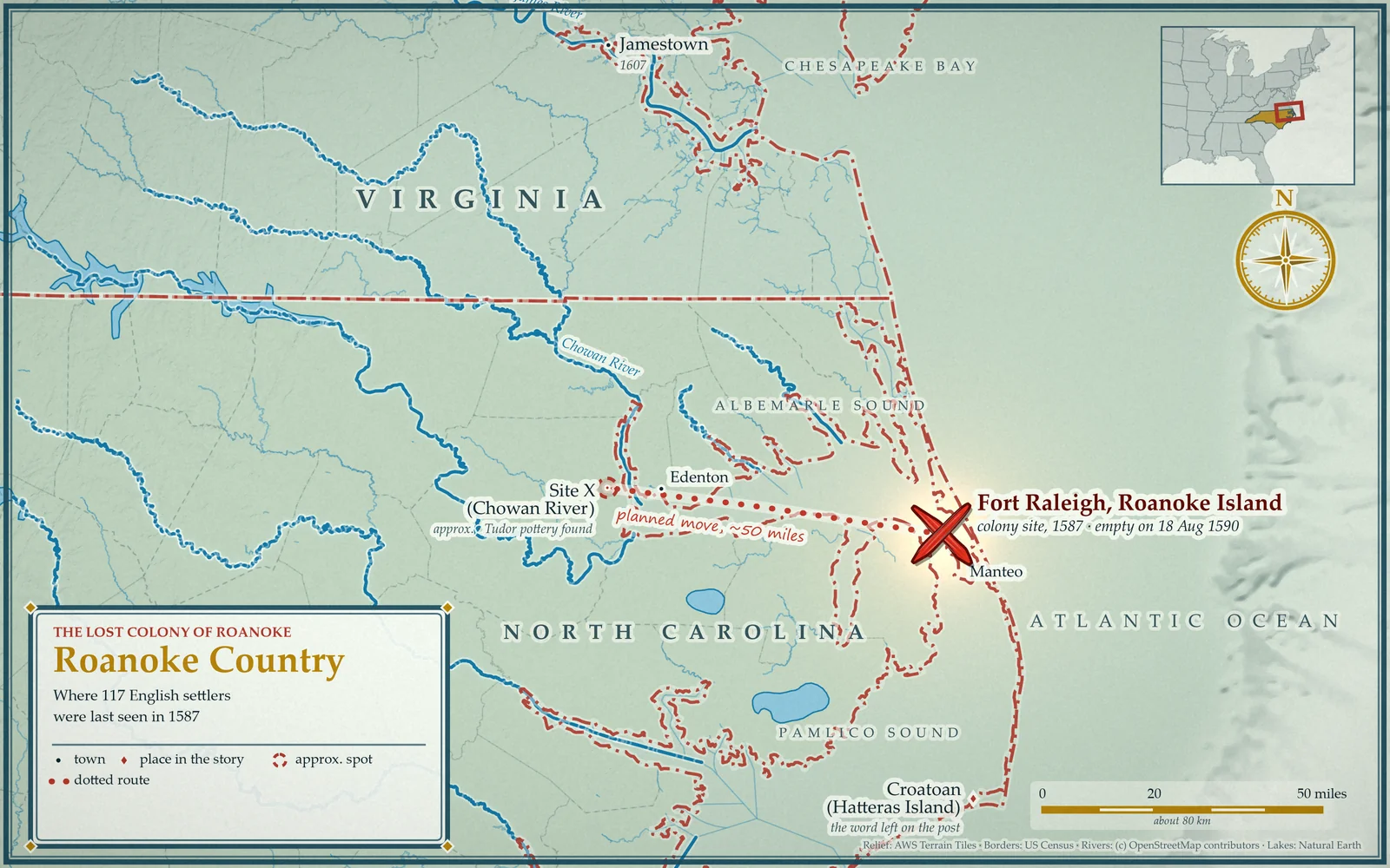
The next move was obvious: sail to Croatoan Island (today's Hatteras Island) and look. But the weather turned, an anchor cable on the Hopewell snapped, and the search ended. The ships were back in England on 24 October 1590, and White apparently never returned to the coast. He never found out.
What CROATOAN really means
It is a decent clue, if you do not overthink it. Croatoan was both a place (an island to the south, today's Hatteras) and the people who lived there. The word was carved in full, with no cross, exactly as the colonists agreed. White took heart from it: no cross meant no distress. It sounds like an orderly departure, not a massacre.
The headache is that it does not say where the colonists went. Meanwhile the records say the colonists had decided to move about 50 miles up Albemarle Sound. A single word on a post does not settle it. The documents never answer the question, which is how a clue became a mystery.
The searches that came after
Ralegh never found the colony. His critics, including Francis Bacon, noted that he did not look very hard. Some argue he found the open question rather convenient, since it kept his claim to Virginia legally alive. In 1594 a petition declared Ananias Dare legally dead so that his son could inherit, which was granted in 1597. Bartholomew Gilbert's 1603 expedition to search ended when he was killed on 29 July.
When Jamestown went up in 1607, the English got another chance to ask questions. They heard stories. In May 1609 the Virginia Council reported that the 1587 colonists had been killed. William Strachey, writing between 1610 and 1612, said seven English had survived and fled up the Chowan River, although his account was not published until 1849. Samuel Purchas in 1625 leaned on an alleged confession by Chief Powhatan, which historian Helen Rountree has called an "anti-Indian polemic". Treat all of it as reported talk, not evidence.
Clues, hoaxes and a map with a secret
The Dare Stones. Between 1937 and 1941 a series of inscribed stones turned up, supposedly written by Eleanor Dare and describing the colonists' travels and deaths. Most historians consider them a fraud. Investigators linked all but one to a stonecutter named Bill Eberhardt. A few people still wonder about the first one, but the whole saga is a lesson in wishful thinking.
The patched map. In November 2011, researchers with the First Colony Foundation noticed two paper patches on John White's 1585 map, La Virginea Pars, held in the British Museum. Light-table examination showed a faint outline of a fort underneath one of them, about fifty miles west of Roanoke. Whether that was meant to mark the colonists' planned destination is an interpretation, and a tempting one.
Site X. That led the foundation to dig in Bertie County on the Chowan River, in or near the Algonquian village of Mettaquem. Archaeologist Nicholas Luccketti gave the place its sensible name, "Site X", in 2012, and a team dug there in 2015. In October 2017 the foundation reported Tudor-era pottery and weapon fragments and concluded that a small group of colonists had lived peacefully there. A lead cloth seal from Augsburg, Germany, suggests civilians rather than soldiers from Lane's earlier expedition. A second location, called Site Y, lies upstream, is badly eroded and has produced more Elizabethan artifacts. The foundation reads that as evidence of a bigger, more independent English settlement. Researchers still need to rule out other explanations, such as Lane's 1585 party or a later trader, and the foundation's "found" headline rests on what it calls possible sixteenth-century sherds and one seal.
Croatoan. Down on Hatteras Island, the Croatoan Project (running since 1998) has turned up European objects in a Native village, including part of a sword and part of a gun. In 2025 researchers reported hammerscale, a forging byproduct, in a layer dated to the late sixteenth century. Skeptics point out that no hearth was found with it and the results have not been peer reviewed.
On Roanoke Island itself. Archaeologists found 16th-century Algonquian pottery and a copper wire ring in the summer of 2023, which suggests contact with the English by trade. It was not proof that the colonists were there, though.
The theories, weighed
- They moved inland (Site X and Site Y). Best supported by today's archaeology and by the map patch, though not settled, and it only covers some of the colonists.
- They joined the Croatan on Hatteras Island. The word on the post points this way, and European objects have turned up there. It is circumstantial, and the hammerscale needs more work.
- They were attacked. David Beers Quinn argued that colonists who had joined the Chesepians were killed by Powhatan's forces around April 1607. The evidence is thin and some of it is nasty colonial propaganda.
- Spanish raiders. Spain looked for the English colony, but its records suggest it was unaware of what had become of it.
- They tried to sail home. The colonists left on a pinnace (a small ship) that may have been lost at sea, though that wouldn't explain the carved word.
- A plot. Lee Miller argued that Sir Francis Walsingham had them marooned to undermine Ralegh. Philip McMullan's "Beechland" theory says Ralegh kept the colony secretly harvesting sassafras. Both lean heavily on oral tradition or speculation.
Then there are the descendants claims. In the 1880s, North Carolina legislator Hamilton McMillan suggested that a community in Robeson County kept surnames and speech from the 1587 colonists, and the state recognised them as "Croatan" in 1885. They adopted the name Lumbee in 1956. Archaeologists have challenged claims that Roanoke settlers merged with the Croatan, citing a lack of supporting evidence. A DNA study of local families has been running since 2007, and the Roanoke-Hatteras tribe identifies as descended from both English and Native ancestors.
Where it stands today
Nobody has found the colonists' bones, a gravestone or a note. The most honest summary is that the evidence points to people leaving in an orderly way, most likely splitting up and living among their Native neighbours, and that the details are still being argued. The First Colony Foundation's claim that the main settlement sat on the Chowan River in Bertie County is the most ambitious one so far, and it will take independent checking before the history books change.
You can walk the ground that is known. Fort Raleigh National Historic Site, at 1401 National Park Drive in Manteo, is run by the National Park Service. It is a protected site, and archaeology there is done by permitted teams, so the digging is best left to them. Bring a hat, a camera and a good ear for local legend.
...and if you find it, remember who encouraged your questionable life choices.
The short version of this story is on YouTube at @TenToeExpress.
Deep dive yourself
- Origins of the Lost Colony Mystery · North Carolina Department of Natural and Cultural Resources
- The Lost Colony at Fort Raleigh National Historic Site · National Park Service
- Roanoke Colony · Wikipedia
- The Mystery of the Lost Roanoke Colony · History Hit
- Lost Colony is Found · First Colony Foundation
- Pottery and Copper Jewelry Unearthed in North Carolina · First Colony Foundation